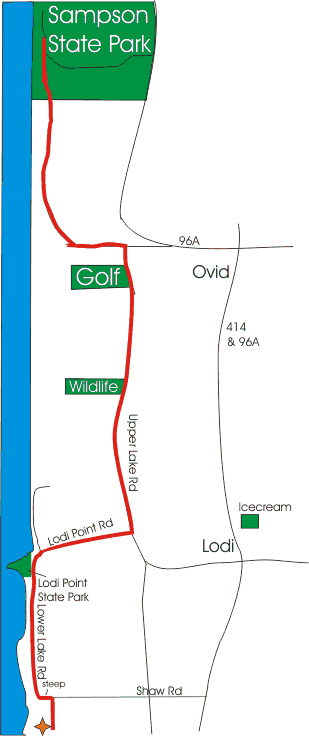
Finger Lakes - Lakeside, Vineyard View and Sampson Biking Trail
 Length: 10 - 25 miles round trip depending
on where you turn around
Length: 10 - 25 miles round trip depending
on where you turn around
Features: A flat easy 1.5 mile ride along
the lake followed by a 1.5 mile climb to Upper Lake Rd. where
you ride by vineyards, Amish and Mennonite farms, a wildlife
refuge and a bar/restaurant all accompanied by grand views
of Seneca Lake. The midpoint of the ride is in the Sampson
State Park where you ride a paved path along the edge of Seneca
Lake. The roads are low traffic country roads in fair condition
and are well suited for bike travel. Shoulders are narrow
however, so be alert.
Difficulty: Moderate
Sights: Lakeshore, ducks, Lodi Point State
Park, Willard Wildlife Management area, Buena Vista Golf Course,
Sampson State Park.
Stops: Lodi Point State Park (restrooms
and picnic tables available)
Willard Wildlife Management Area
Buena Vista State Golf Course and Clubhouse
Sampson State Park
Naval Training Base Museum
Road Directions:
- Turn left out of Lodi point State Park
- Keep Right onto Lodi Point Rd and head up hill for a semi-gradual 1.5 mile climb.
- At the stop sign turn left onto Upper Lake Road (heading
North).
- At 4 miles you will see the Willard Wildlife Management
Area on your left. (a good place to stop for a break
and a short hike if you'd like)
- Continue on Upper Lake Rd. for a mile and the
Buena Vista State Golf Course will be on your left. (Their
Clubhouse is also not a bad place to stop for a drink and
a sandwich.)
- Continue past the golf course for 1/10 mile.
- Turn left at the stop sign (Willard Drug Treatment Center
on the corner)
- This road heads down toward the water (slight hill) and
ends at the beginning of the Sampson State Park Trail.
- Continue into Sampson State Park and ride along the lake.
- Venture as far into the park as you would like. There
is a Naval Training Museum inside the park.
- Reverse directions to return to Lodi Point State Park
The view on the return trip is almost completely different
as you are now facing the southern end of the lake, however
you could follow the directions below to get to Rt 96A &
414 and use that as the path to return toLodi Point State Park.
If you choose this return path, please use caution as there
is a lot more traffic moving at high speeds.
- Head for the park's main entrance / exit
- Turn right onto Rt 96A (you are now headed South)
- Follow Rt 96A for ~ 5 miles where it turns East (an uphill
climb) for 1 mile.
- When you reach the flashing red light in Ovid, turn right
onto Rt 414S and 96A.
- You will pass through the village of Ovid (stop anywhere
that catches your interest)
- Follow Rt 414 five miles to Lodi.
- There will be an ice cream/soda stand on your left (stop
if you'd like)
- 1 block past the Ice cream stand turn right onto Lodi Station Rd
- Follow it for roughly a mile and turn left on Lodi Point Rd. to return to Lodi Point State Park
|